The Claim Post
...the most trusted name in gold property listings
High-grade mineral properties for lease & for sale
A World-Class Gold Mining Property Listing
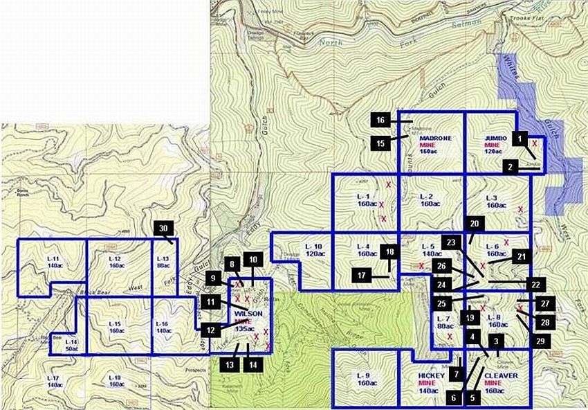
Map 5
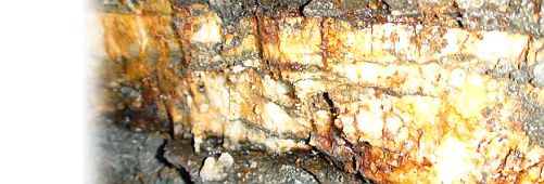
In discovering just 1-vein occurrence, should produce approximately $20M
The State of California Division of Mines has documented that most single vein occurrences is about $20M at today’s price. In most instances, there were/are multiple fault/vein systems within each of these mines.
Known past producing gold mines reside within this collection. The highest concentration of prospects in the richest gulch/most proven area in the Liberty District. There are (at least) 30 historic gold mining sites within the Liberty Mines Group. In addition to these 30 past producers, there are dozens of additional gold mining prospect sites throughout.
Kramer patent
North Fork Salmon River
Siskiyou County, California
What other gold property listing gives you this kind of gold production history head-start?! Could be quite a treasure map.
The mines, numbered on this map that correspond with the list below, reside within The Liberty Mines Group. Un-named or un-known prospects within the group are marked with a red "X". It is likely that there are dozens of additional prospect sites and additional mines within this group. The gray shaded areas are patented properties. The areas shaded in green & in violet are unpatented properties belonging to others.
This map is far from complete.
1. The Jumbo Mine Host claim: Jumbo Mine, 120 Acres
1894 CALIFORNIA JOURNAL OF MINES AND GEOLOGY, VOL 12-13, P. 409
Samples Assayed at $20/ton (AU at $20.67 p/oz), ore slimed excessively and recovery was about 20% by amalgamation. 10-stamp mill on site with a number of adits on the west side of the gulch. 86 ft adit on verticle vein w/44 ft. wince; 68 ft crosscut to vein. Vein is 1.52 meters thick. Reported in 1897: The developments consist of three tunnels, 60', 120' and 200' long, all on the vein. The ore is white quartz, with some sulphurets. In the middle tunnel the vein is 4 feet thick, and arrangements have been made to stope. The ore is to be run to the mill through a chute 4' wide. The mill stands near the creek and has 10 stamps of 750 lbs, No 9 screens, 12' of amalgamated plates, and is driven by a 30" Pelton wheel under 200' of pressure. Dr. H.C. Helm et al of Sawyers Bar, owners.
2. Ruby Basin Mine Host claim: Jumbo Mine, 120 Acres
1915 MINES AND MINERALS OF SHASTA, SISKIYOU, AND TRINITY COUNTIES
Owner at one time was I. Cullberg Jr from Arcata. Mine comprised of 100 acres on Whites Gulch, 160 foot ore shoot, free milling on 3 foot wide vein with a north and south strike of 40E, in slate host. 800 foot tunnel with 500 feet of drifts and a 60 foot stope. 10-stamp mill driven by water power. Ruby Basin Mine was formerly known as the Jumbo mine, and work continued under that name.
3. Cleaver Mine Host claim: Cleaver Mine, 160 Acres
CRAWFORD, J.J., 1894, REPORT OF THE STATE MINERALOGIST: CALIFORNIA JOURNAL OF MINES AND GEOLOGY, VOL. 12, P. 279
Total production for the Cleaver Mine was about $75,000 ($20.67 p/oz, or approximately 3,600 ounces). Included the Brown Bear Mine/Claim, the Crystal Mine/Claim, and the Golden & Eveleth Mine/Claim. The Crystal Claim at the Cleaver Mine site reported $35,000 in recovery, paid $8.10/Ton in free gold from milling, 0.869 pure. Last production from the mine was in 1909. Numerous crosscuts, stopes and drifts. See Brown Bear and the Golden & Eveleth Mine data on this page for additional information about the other operations at the Cleaver Mine.
4. Brown Bear Mine Host claim: Cleaver Mine, 160 Acres
CRAWFORD, J.J., 1894, REPORT OF THE STATE MINERALOGIST: CALIFORNIA JOURNAL OF MINES AND GEOLOGY, VOL. 12, P. 279
The Brown Bear claim, along with the Eveleth Claim (also part of the Cleaver Mine) is credited with a production of $40,000. A 4-stamp mill was operated driven by water power from Whites Gulch through 1 1/2 miles of ditch and 1/2 mile of flume. The lowest adit on the Brown Bear was open for 200 ft, 300 ft below the summit. Another crosscut was at 200 ft at the point where it crosses the maximum thickness of the vein, followed vein for 160 feet. Multiple crosscuts, stopes, and drifts. Elevation of 3,100 ft, owners were Swain and Cleaver at one time, comprised of 100 acres on Whites Gulch. 18 inch wide vein with a course of N20E and a dip of 25E. Expanded tunnel to 480 feet. See the Cleaver Mine and the Golden and Eveleth Mine data on this page for addition information about the other operations at the Cleaver Mine.
5. Golden & Eveleth Host claim: Cleaver Mine, 160 Acres
CRAWFORD, J.J., 1894, REPORT OF THE STATE MINERALOGIST: CALIFORNIA JOURNAL OF MINES AND GEOLOGY, VOL. 12, P. 279, Vol 13 P. 402.
The Golden & Eveleth Mine/Claim was a part of the Cleaver Mine, along with the Brown Bear Mine/Claim and the Crystal Mine/Claim. The Eveleth and Brown Bear is credited with an estimated production of $40,000, the Crystal Mine/Claim at $35,000 from a lode of quartz from which sulfides assayed well at $8.10 p/ton in free gold from milling. There was a 4-stamp mill in operation, run by water. The stamps weigh 750 lbs and drop 7" 90 times per minute. Multiple levels of adits, crosscuts, and stopes on the vein. Vein averages 4 ft in thickness and lies between porphyry and slate, dips 45 to 70 degress North. The mine is worked in two tunnels 165' and 450' long, connected by a winze. The ore-shoot is 175' long and the ore contains about 1% of sulphurets. Frank Golden et al of Sawyers Bar, owners (1894).
6. Keaton Mine Host claim: Cleaver Mine, 160 Acres
AVERILL, C.V., 1935, MINES AND MINERAL RESOURCES OF SISKIYOU COUNTY, CALIFORNIA: CALIFORNIA JOURNAL OF MINES AND GEOLOGY, V. 31, NO. 3, P. 291 PL.
Dubois took 108 post hole auger samples but only to a depth of 6 feet. Assays from those samples came back at $3.60 p/ton in gold (20.67 p/oz), or about 1/5th of an ounce per ton. In one place, a width of 120 ft was sampled with a row of 10 different holes. There are cuts, open pits, and a millsite.
7. Hickey Mine Host claim: Hickey Mine, 140 Acres
AVERILL, C.V., 1935, MINES AND MINERAL RESOURCES OF SISKIYOU COUNTY, CALIFORNIA: CALIFORNIA JOURNAL OF MINES AND GEOLOGY, V. 31, NO. 3, P. 287-8, PL. 4
Underground operations, 75 tons of ore were recovered and yielded $35 per ton, or 1.5 ounces p/ton. Additional assays were made some time prior to 1935 at $3.37 p/ton at $20.67 p/ounce. Millsite and multiple adits, the longest being 400 feet long.
8. The Wilson (Wilson Bros.) Mine Host claim: Wilson Mine, 135 Acres
LOGAN, C.A., 1924, SACRAMENTO FIELD DIVISION: CALIFORNIA JOURNAL OF MINES AND GEOLOGY, VOL. 21, NO. 4, P. 461
Several short adits with the lowest 150 ft long with 36 ft of drift. 40 ft above the lowest is a second adit which runs 170 ft, 36 ft is on the vein. The upper adit was 25 ft above the second and on the vein for 100 ft. A small mill was utilized here.
9. Roberts Mine Host claim: Wilson Mine, 135 Acres
1894 CALIFORNIA JOURNAL OF MINES AND GEOLOGY, VOL 12-13, P. 422
It lies at the head of Eddy Gulch, 4 miles south of Saywers Bar at 3,600' elevation. The vein is exposed in two tunnels, 90 ft long and 115 ft long. The tunnels are on 10" to 18" of white quartz. The ore is treated at an arrastra run by an overshot wheel. Eddy Roberts, of Sawyers Bar, owner (1894).
10. Hibernia Mine Host claim: Wilson Mine, 135 Acres
1894 CALIFORNIA JOURNAL OF MINES AND GEOLOGY, VOL 12-13, P. 417
Also called the Ninety Mine. Portions of this mine are located near the Wilson Mine. Ore was free milling with no production records found. Operations were underground to a depth of 45.72 meters. There was one 60 ft shaft, one 200 ft adit, and one 100 ft drift. The vein, dipping 40 degrees N/NW, shows 6" to 36" of white quartz, with some sulphurets. In 1894, J.W. Murray of Sawyers Bar was listed as the owner.
11. Liberty Mine Host claim: Wilson Mine, 135 Acres
1894 CALIFORNIA JOURNAL OF MINES AND GEOLOGY, VOL 12-13, P. 409
There were 3 adits on this site, 25 ft long, 50 ft long, and 80 ft long. The ledge is from 3' to 8' wide.There was also a 90 ft incline. The ore body was quite thick here at 2.44 meters on a Dip of 20E. No production data is available. Stevens, Grant, and Hughes, of Sawyers Bar, owners.
12. Live Yankee Mine Host claim: Wilson Mine, 135 Acres
VOL 2, NUMBER 10, SISKIYOU PIONEER (1957), PAGES 3-4 REFERENCED HERE
The Live Yankee Mine, discovered by Charles Nash, was the second quartz mine to be established at the head of Eddy Gulch in 1860 and was the home to the second mill in the region. In 1905 John daggett compiled records of mineral wealth of this specific region, records available he estimated that the Live Yankee Mine recovered $75,000 in gold from 1860-1904. Portions of the Live Yankee Mine reside within the Liberty Mines Group. Mr. Daggett's estimates and his recordings can be found in Volume 2, Nubmer 10, of the Siskiyou Pioneer, from 1957 and reproduced in 2001 by the Siskiyou County Historical Society. This book of personal experiences and research can be purchased only at the Museum in Yreka, California. We highly recommend this book as it is filled with first hand accounts of the mining operations in this very region.
13. Snowflake Mine (Bear Den) Host claim: Wilson Mine, 135 Acres
CA JOUR MN/GEOL V 31, NO 3, 1935, P 327
Also called the Bear Den and the Little Gem. The Snowflake claim has produced $8,000 or more, with the last few tons having yielded $23 p/ton at $20.67 p/ounce.
14. Oriental Quartz Mine Host claim: Wilson Mine, 135 Acres
LOGAN, C.A., 1925, SACRAMENTO FIELD DIVISION: CALIFORNIA JOURNAL OF MINES AND GEOLOGY, VOL. 21, NO. 4, P. 453
The host rock is described as black and slaty. It is thought that heavy gouge was caused by hillside drag along the plane of the vein. Vein thickness is .91 meters, or just under 3 feet in thickness. Adit on site, trends N55W for 112 feet. No production data.
15. Madrone Mine Host claim: Madrone Mine, 160 Acres
CA JOUR MN/GEOL V 31, NO 3, 1935, P 324
Also called the Neilon and Putnam Mine, which had multiple locations around the Madrone Mine complex. This site had only a few tons of ore crushed at a small mill. No production record has been found.
16. Neilon & Putnam Mine Host claim: Madrone Mine, 160 Acres
CA JOUR MN/GEOL V 31, NO 3, 1935, P 324
Also called the Madrone Mine, which had multiple locations in the immediate vicinity. This site had only a few tons of ore crushed at a small mill. No production record has been found.
17. Sheffield Mine Host claim: L-4, 160 Acres
CRAWFORD, J.J., 1894, REPORT OF THE STATE MINERALOGIST: CALIFORNIA JOURNAL OF MINES AND GEOLOGY, VOL. 12, P. 291
This portion of the Sheffield Mine is located north of the Uncle Sam Mine workings. Portions of the mine are located within the Liberty Mines Group on claim L-4. The Sheffield Mine had several thousand feet of tunneling following a 2.44 meter thick quartz vein in blanket form. Ore was processed at an 8-stamp millsite.
18. Stevens & Hughes Mine Host claim: L-4, 160 Acres
COOPER, A.S., 1900, REGISTER OF MINES AND MINERALS, COUNTY OF SISKIYOU, CALIF.: CALIF. STATE MINING BUREAU
The ore from the Stevens & Hughes Mine was free-milling ore. The workings were underground to a depth of 9.14 meters (less than 30 feet). There was an adit with length of 50 feet. No production record has been found.
19. Claus Peters Mine Host claim: L-8, 140 Acres
COOPER, A.S., 1900, REGISTER OF MINES AND MINERALS, COUNTY OF SISKIYOU CALIF.: CALIF. STATE MINING BUREAU
The ore from the Claus Peters Mine was free-milling ore. The workings were underground and there is record of a 100 foot adit. No production record has been found.
20. Keaton Mine Host claim: L-6, 160 Acres
AVERILL, C.V., 1935, MINES AND MINERAL RESOURCES OF SISKIYOU COUNTY, CALIFORNIA: CALIFORNIA JOURNAL OF MINES AND GEOLOGY, V. 31, NO. 3, P. 291 PL.
Dubois took 108 post hole auger samples but only to a depth of 6 feet. Assays from those samples came back at $3.60 p/ton in gold (20.67 p/oz), or about 1/5th of an ounce per ton. In one place, a width of 120 ft was sampled with a row of 10 different holes. There are cuts, open pits, and a millsite.
21. Captain Smith Mine Host claim: L-6, 160 Acres
COOPER, A.S., 1900, REGISTER OF MINES AND MINERALS, COUNTY OF SISKIYOU, CALIF: CALIF. STATE MINING BUREAU
Underground workings to a depth of 15.24 meters (45 feet). There is a 200 foot adit and a 100 foot drift. No production data has been found.
22. Peters Mine Host claim: L-6, 160 Acres
CRAWFORD, J. J., 1896, REPORT OF THE STATE MINERALOGIST: CALIFORNIA JOURNAL OF MINES AND GEOLOGY, VOL. 13, P. 420
At 4,725’ elevation. The vein here is 8” thick and lying in slate. There are two tunnels, one at 60 feet of length, and the other at 160 feet of length, both are on the ledge. Peters Brothers, of Sawyers Bar, owners.
23. Osceola Mine Host claim: L-6, 160 Acres
CRAWFORD, J. J., 1896, REPORT OF THE STATE MINERALOGIST: CALIFORNIA JOURNAL OF MINES AND GEOLOGY, VOL. 13
Multiple mining Osceola mining sites exist within the L-6 claim. (1894 report) The older workings are not extended to the vein. Ore is being quarried from the croppings in open cuts. A 5-stamp water-powered mill belonging to the property stands 1,000’ below. The stamps weigh 850 lbs; No 9 slot screens and 12’ of silvered plates are used. Osceola Consolidated Gold Mining Co, owner, F.D. Moneton of San Francisco.
24. Franks & Moneton Mine Host claim: L-6, 160 Acres
CRAWFORD, J.J., 1894, REPORT OF THE STATE MINERALOGIST: CALIFORNIA JOURNAL OF MINES AND GEOLOGY, VOL. 12, P. 282
Also spelled as "Monotone Mine", 2 adits, 125 feet and 150 feet long each, 60 ft drift on the vein and another lower adit that is 340 feet long. Shafts are present as well as an old millsite. No production data is available.
25. Lewis Mine Host claim: L-8, 160 Acres
CRAWFORD, J.J., 1896, THIRTEENTH REPORT OF THE STATE MINERALOGIST: CALIFORNIA JOURNAL OF MINES AND GEOLOGY, VOL. 13, P. 412
There is a millsite recorded on this mine but no production data.
26. Osceola Mine Host claim: L-6, 160 Acres
CRAWFORD, J. J., 1896, REPORT OF THE STATE MINERALOGIST: CALIFORNIA JOURNAL OF MINES AND GEOLOGY, VOL. 13
Multiple mining Osceola mining sites exist within the L-6 claim. (1894 report) The older workings are not extended to the vein. Ore is being quarried from the croppings in open cuts. A 5-stamp water-powered mill belonging to the property stands 1,000’ below. The stamps weigh 850 lbs; No 9 slot screens and 12’ of silvered plates are used. Osceola Consolidated Gold Mining Co, owner, F.D. Moneton of San Francisco.
27. Deer Lodge Mine Host claim: L-8, 160 Acres
CRAWFORD, J.J., 1896, REPORT OF THE STATE MINERALOGIST: CALIFORNIA JOURNAL OF MINES AND GEOLOGY, VOL. 13, P. 396-397
There are 2 adits on site, one 75 feet long and the other is 80 feet long. The quartz vein is 6” thick, owned by Smith and Eveleth of Sawyers Bar.
28. White Elephant Mine Host claim: L-8, 160 Acres
CRAWFORD, J.J., 1896, THIRTEENTH REPORT OF THE STATE MINERALOGIST: CALIFORNIA JOURNAL OF MINES AND GEOLOGY, VOL. 13, P. 431
Situated on Whites Gulch, 6 miles south of Sawyers Bar at 4,140’ elevation. The 4 foot ledge of quartz is exposed by several open cuts. Smith & Eveleth, of Sawyers Bar, owners. Due to proximity, the White Elephant Mine may have been operated by Scott Bar Mines, Inc. USGS Deposit ID: 10036250, see below.
29. Scott Bar Mines, Inc. Host claim: L-8, 160 Acres
CRAWFORD, J.J., 1896, THIRTEENTH REPORT OF THE STATE MINERALOGIST: CALIFORNIA JOURNAL OF MINES AND GEOLOGY, VOL. 13, P. 431
It appears from reference material that Scott Bar Mines Inc operated the White Elephant Mine at some point in history. The White Elephant Mine was situated on Whites Gulch, 6 miles south of Sawyers Bar at 4,140’ elevation. The 4 foot ledge of quartz is exposed by several open cuts. Smith & Eveleth, of Sawyers Bar, owners.
30. Paymaster Mine Host claim: L-13, 80 Acres
1894 CALIFORNIA JOURNAL OF MINES AND GEOLOGY, VOL 12-13, P. 420
Surface and underground workings. Overall depth is 45.72 meters. There is an incline 50’ deep and a tunnel 60’ long, with a short winze on the claim. The vein is 3 feet thick, and the ore is a reddish quartz, with a large percentage of sulphurets. The dip is nearly perpendicular and the strike is N 70 Degrees. Also present is an open cut, 20 ft in length, and a 210 ft adit. W. James Patterson and Edgar Wallace, of Sawyers Bar, owners.
The Claim Post. High Grade Gold Properties For Lease & For Sale. © Copyright 2003 to present. All rights reserved.
Note: This map is accurate for illustrative purposes only. The full legal description of these mining claims are on public record at the Bureau of Land Management, Sacramento, CA.
The Liberty Mines Group
21 unpatented mining claims - apprx. 2,900 acres
Located On The Historic Billion Dollar Black Bear & Eddy Gulch Trends
Liberty Mining District, Siskiyou County, CA
Located in the heart of one of the richest gold producing trends in the United States.